New Zealand's Most Incredible Mountains

New Zealand is surrounded by breathtaking backdrops at every turn, and both islands are set to amaze visitors with their majestic mountains. Prepare to be inspired as we head on a journey across some of the country’s most incredible peaks.
Did you know – Culture Trip now does bookable, small-group trips? Pick from authentic, immersive Epic Trips, compact and action-packed Mini Trips and sparkling, expansive Sailing Trips.
Mount Taranaki

Also known as Mount Egmont, Mount Taranaki is a quiescent stratovolcano (in between active and dormant) on the west coast of the North Island. Soaring up high at a majestic 2,518 metres (8,261 feet), the mountain has one of the most symmetrical volcanic cones in the world. A semblance to Japan’s Mount Fuji has also given Mt Taranaki a bit of cinematic acclaim – if you’ve seen the Tom Cruise blockbuster The Last Samurai, this is where those mountain backdrops were filmed.
The Remarkables
The aptly-named Remarkables are a mountain range and ski field in Otago. They adorn the southeastern shores of Lake Wakatipu, creating an impressive backdrop for its closest town – Queenstown. The range’s highest point is Double Cone, which has a height of 2,319 metres (7,608 feet). There are number of lakes dotted around The Remarkables, including the glacial Lake Alta, which freezes over in the winter months as the area transforms into a prime skiing and snowboarding destination.
Mount Ngauruhoe
Mount Ngauruhoe has earned international acclaim after being selected to depict Mount Doom in The Lord of the Rings trilogy. This active volcano is the youngest vent among the Tongariro volcanic complex, first erupting around 2,500 years ago. It is surrounded by Mt Tongariro to the north, Mt Ruapehu to the south and Rangipo Desert to the west. Ngauruhoe has erupted 45 times in the 20th Centrury, the most recent being in 1974. Sulphurious gases are still being emitted from the crater – climbers with asthma have been known to be affected by this.
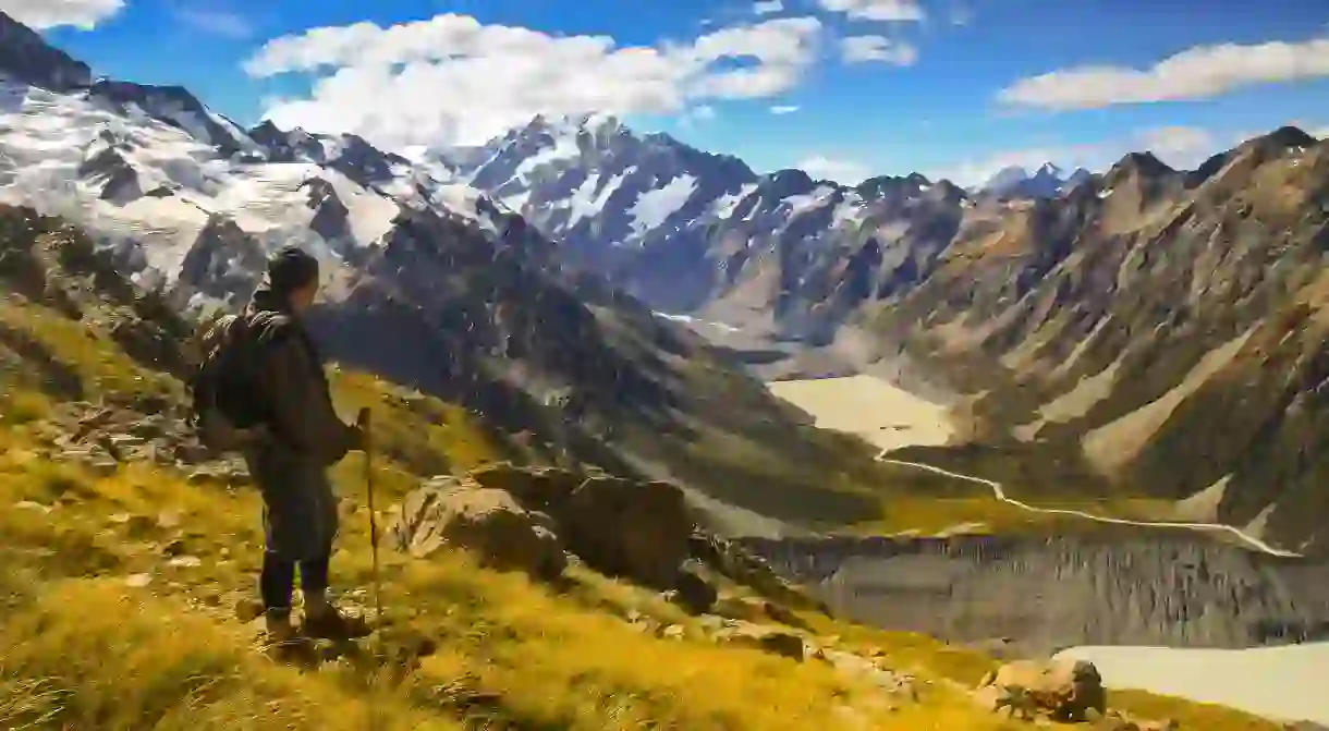
Aoraki/Mount Cook

With a height of 3,724 metres (12,218 feet), the snow-capped Aoraki/Mount Cook is the highest mountain in New Zealand. Part of the Southern Alps, a range that stretches across the entire South Island, the mountain is made up of three distinct summits that neighbour the Tasman Glacier to the east and the Hooker Glacier to the southwest. Aoraki/Mt Cook is a popular destination for experienced mountaineers looking for a challenge – in fact, before ascending to the summit of Mount Everest, Sir Edmund Hillary went on an expedition to conquer his homeland’s most difficult glacial climb.
Mount Tasman
Mount Tasman is New Zealand’s second highest mountain, rising to a respectable 3,497 metres (11,473 feet). You’ll find it just north of Aoraki/Mt Cook in the Southern Alps. It sits on the South Island’s Main Divide, which is the politically established boundary between the Canterbury and West Coast regions. As with Aoraki/Mount Cook, Mount Tasman is a favourite among avid climbers.
Tititea/Mount Aspiring
Set within Otago’s Mount Aspiring National Park, Tititea/Mount Aspiring is the highest mountain outside of the Aoraki section of the Southern Alps. Its pyramidal peak rises to 3,033 metres (9,951 feet) in height, and is the inspiration for the mountain’s Maori nomenclature: Tititea can be translated as ‘Glistening Peak’. Climbers usually scale Mount Aspiring via West Matukituki Valley, located 50 kilometres (31.1 miles) from the national park’s nearest town, Wanaka. The mountain also lies close to three major glacial systems: the Bonar Glacier, which drains into the Waipara River, and the Volta and Therma Glaciers, which drain into the Waitoto River.
Mitre Peak

Mitre Peak is probably one of the most iconic South Island mountains. It lies on the shores of the Milford Sound, which is largely revered for its hiking terrain and sublime scenery. A distinctive peak shape that largely resembles a Christian bishop’s mitre headwear is what gives this mountain its name. Mite Peak has a height of 1,690 metres (5,560 feet) and is very difficult to climb. Boat cruises are the best way to see this natural wonder up close.
Mount Tarawera
Mount Tarawera was responsible for one of the largest volcanic eruptions in New Zealand’s history. This North Island volcano is situated just 24 kilometres (14.9 miles) outside of Rotorua, and consists of an awe-inducing series of lava dome fissures that were melded by its most recent – and most destructive – eruption, which occurred in 1886 and took the lives of approximately 120 people. These days, the Tarawera Trail is one of best ways to get familiar with this mountain’s landscape. There are also guided tours around Mount Tarawera for those who want to get a bit of local insight into this volcanic behemoth.
Mauao/Mount Maunganui
Mauao or Mount Maunganui is an extinct volcanic cone that is considered to be sacred by the local Maori iwi. The name Mauao literally translates as ‘caught by the morning sun’, and comes from a legend in which a nameless mountain, spurned by unrequited love, begged some fairy-like creatures to drag him into the ocean to end his misery. As the morning sun’s rays struck the mountain, the magical creatures fled – leaving the once-nameless mountain where it resides today. Mauao is located in the peninsula and town of Mount Maunganui, along the eastern end of the Tauranga Harbour, and its summit sits 232 metres (761 feet) above sea level.
Read Next

The Coolest Neighbourhoods in Wellington, New Zealand

17 Natural Wonders in New Zealand That Will Take Your Breath Away

The 5 Most Hipster Neighborhoods in Auckland, New Zealand

8 Maori Sayings You Need To Know Before You Travel

How To Spend Christmas in Queenstown, New Zealand

These Are the 10 Most Spectacular Glow Worm Caves in the World

The Best Cultural Experiences to Try in New Zealand

The Best Things to Do in Wellington at Night

The 9 Best Things to Do in New Zealand in Winter

20 Must-Visit Attractions in Waikato, New Zealand

The Real Maori and Pacific Legends That Inspired Disney's Moana

The Most Beautiful Towns in New Zealand
