A Traveller's Guide to Tramping The Tongariro Alpine Crossing, New Zealand

The Tongariro Alpine Crossing is arguably one of New Zealand’s most popular day hikes. With its dramatic volcanic landscapes, exquisite glacial valleys, ancient lava flows and spectacular alpine terrains, the journey is as breathtaking as it is physically demanding.
The challenging, 19.4-kilometre (12.1-mile) trek starts at an altitude of 1,120 metres (3,675 feet) and continues to ascent until it reaches its highest point, the Red Crater, which sits at a whopping height of 1,886 metres (6,188 feet).
It pays to keep a close eye on the weather if you’ve got your sights set on the Tongariro Alpine Crossing. Even in summer Tongariro National Park’s alpine weather conditions are notorious for making its hiking trails quite risky to navigate. Temperatures can change quite rapidly within a few hours and you might experience some strong wind gusts and high rainfall periods.
The trip can become even more treacherous in winter. Sub-zero temperatures, reduced daylight hours and the propensity of ice and snow will make sections of the crossing quite slippery, hard to navigate and prone to avalanches. If you don’t have prior backcountry hiking experience, it’s best to wait until the snow recedes before you tackle the crossing; if you’re well-versed in this kind of terrain, make sure to bring an ice axe and crampons with you.

Whatever time of the year you decide to tackle the Tongariro Alpine Crossing, you need to ensure you’ve got all the provisions required for a full day of tramping. This includes plenty of drinking water–because there won’t be any places to fill up your water bottles along the way–as well as sturdy boots, windproof clothing, sunscreen (both in summer and winter), a head torch, first aid kit, your mobile phone and lots of warm layered clothing.
Arranging transport to the crossing and back is another thing you need to plan in advance. There are various bus and shuttle operators in the national park that offer to drop off and pick up visitors doing the Tongariro Alpine Crossing. Some of the local accommodation providers also offer this as a complimentary service.
Transport operators will actually drop you off right at the start of the track on Mangatepopo Road. This first section is relatively flat, traversing a well-formed boardwalk lined with marker poles for ease of navigation. Within the first 15 minutes of this one to one-and-a-half hour stretch, a sidetrack to Whakapapa emerges on the right; not too far ahead, another track branches off to the left to lead hikers into the Magatepopo Hut and public toilet facilities. If you don’t want to make any detours, continue straight ahead and up the valley, contouring the Mangatepopo Stream as you reach the edge of a lava flow to enter into Soda Springs.
Just a heads up: Soda Springs is the last place with toilet facilities before you reach the Ketetahi Shelter at the end of the Tongariro Crossing. Take a comfort stop if needed before tackling the next stages of the journey.

The route from Soda Springs to South Crater is known as the Devil’s Staircase because of its steep ascent some 1,400-1,600 metres (4,593-5,249 feet) above sea level. Allow at least 40 minutes for this part of the trip, and remember to pace yourself as you trek over the layered lava flows and rocky volcanic deposits. The countryside vistas will make this careful tread worthwhile–on a clear day you might even be able to spot the symmetrical Mount Taranaki summit from afar.
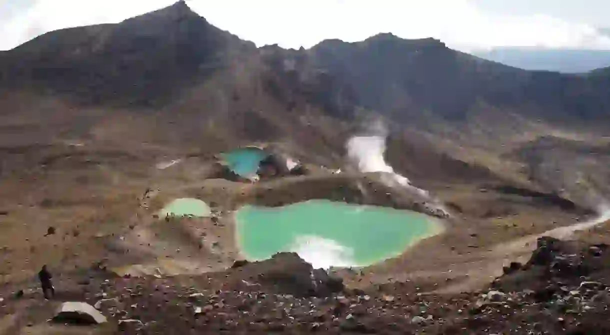
The South Crater eventually emerges on the left. From there, you’ll make a short climb over an exposed ridge that will meander towards the Red Crater. Continue around the Red Crater to revel in the sublime vistas on show. Highlights include the Oturere Valley, Rangipo Desert, Kaimanawa Ranges and the glacial Emerald Lakes. On a windy day this part of the trail can become quite blustery–hike with caution and allow yourself an hour to get through it.

Now we start venturing downwards from Red Crater to the Blue Lake. Watch your footing here: loose scoria underfoot can make this descent quite slippery. On the way down you might spot the track to Oturere Hut just past the lowest lake–that is part of the Tongariro Northern Circuit, a multi-day trek famous for being among New Zealand’s nine Great Walks.
It won’t take long until the Tongariro Alpine Crossing meanders around the edge of the Central Crater to climb up to the acidic Blue Lake. Maori consider the Blue Lake to be sacred (tapu), meaning that it is disrespectful to enter, touch or even eat and drink in its vicinity.

From the lake you’ll head on an easy climb to the edge of North Crater. This is another place to spend some time admiring the natural landscapes: in good weather Mount Pihanga, Lake Rotoaira and even Lake Taupo can be viewed from faraway.
Zig-zag down the Red Crater to reach the Ketetahi Shelter. Just don’t swerve off the main track as the ground can be quite muddy and its pumice base is known for being quick to erode.
From Ketetahi Shelter you’ll head over to Ketetahi Car Park, a moderate trek that typically takes approximately two hours to complete. Part of the route passes by private land, so don’t veer off track at this point. You’ll cross a stream that flows from Ketetahi Springs, following a poled trail down the open tussock and into a clearing.
There are seats around the clearing if you need a quick breather; otherwise, follow the track as it makes its steep descent towards the Maungatetipua Stream. If you want to make a quick detour before calling it a day, there’s a short side track to a waterfall just a few minutes before the Ketetahi Car Park emerges.


