A Guide to the Great Lakes of North America

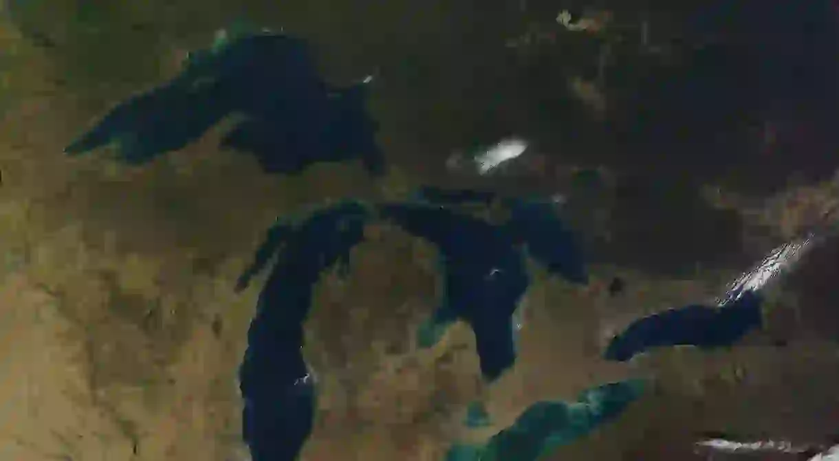
Situated in the northeast of North America, the Great Lakes make up the largest group of freshwater lakes on Earth, accounting for just over a fifth of the world’s surface fresh water. Forming much of the US-Canada border, many of each country’s great cities were founded on the transport and industry afforded by the interconnected chain of five lakes, from Chicago and Detroit to Toronto and Montreal. They also provide beautiful coasts and beaches, tourist towns and endless recreation opportunities. Here’s what you need to know about the continent’s most majestic bodies of water.
Lake Superior
The largest of the Great Lakes is also America’s largest lake and the world’s largest by surface area (though only the third-largest by volume). For comparison, its 31,700 square miles are roughly the size of South Carolina, and it remarkably contains more water than the other four Great Lakes combined. Positioned between the US states of Michigan, Wisconsin and Minnesota, and the Canadian province of Ontario, its size has inspired various names across history, from the Ojibwe name gichi-gami meaning “great sea” to the French le lac supérieur, meaning “Upper Lake.”It finally received its current English name when Britain took control of the region in the 1760s. In popular culture, its most famous shipwreck was immortalized in Canadian singer-songwriter Gordon Lightfoot’s 1976 song, “The Wreck of the Edmund Fitzgerald.” It is connected to Lake Huron by the St. Mary’s River.

Lake Huron
Depending on how you measure these things, Huron is either the second or third-largest of the lakes. By surface area it’s second but by volume it’s third, being surpassed by its neighbor Lake Michigan. It’s named for the indigenous Huron people inhabiting the area when French explorers first arrived in the 17th century. It also forms the border between the US and Canada, specifically Michigan and Ontario, and contains the largest freshwater island in the world, Manitoulin Island. Its main outlet is the St. Clair River, which drains into the lake of the same name and, eventually, Lake Erie.

Lake Michigan
Huron’s westerly counterpart is Lake Michigan, connected to it by the Straits of Mackinac. Though the two are hydrologically a single lake because they share the same elevation, early explorers mistakenly took them for two separate lakes and named them accordingly, and they have remained that way. Its name means “great water” from the Ojibwe word michi-gami, meaning the lake gave the state its name and not the other way around. The only one of the Great Lakes entirely in the US and the world’s largest lake in only one country, it is surrounded by Wisconsin, Illinois, Indiana, and Michigan, and played a key role in the development of cities such as Chicago and Milwaukee.

Lake Erie
Named by the Native American Erie people, Lake Erie is the fourth-largest lake by area but also the shallowest, making it the smallest by volume. Forming another part of the US-Canada border, it separates Michigan, Ohio, Pennsylvania, and New York from Ontario. During the war of 1812, the Battle of Lake Erie saw the United States Navy score an important victory over the British Royal Navy. Connected to Lake Ontario by the Niagara River, its natural outflow is responsible for the world’s most famous waterfalls, which provide enough hydroelectricity to account for a quarter of the power used by both New York State and Ontario.

Lake Ontario
Lake Ontario means “Lake of Shining Waters” from the Huron language word Ontarí’io, and like Lake Michigan, the province of Ontario was named after the lake. It is the smallest of the Great Lakes by area, but still ranks as the world’s 13th-largest lake. It does however have a greater volume than Lake Erie due to a much greater average depth. Sitting between New York State and Ontario, as the last link in the Great Lakes chain, its outlet the Saint Lawrence River eventually reaches the Atlantic Ocean.


